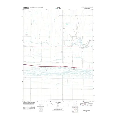
2011 Map of Alfalfa Center
USGS Topo · Published 2011About this map
Alfalfa Center serves as the focal point of this Platte River valley survey, which illustrates the complex water management systems of central Nebraska. The landscape is defined by the braided channels of the Platte River and the North Channel Platte River, separated by features like Long Island. This intricate hydraulic network includes the Kearney Canal, which winds through the terrain alongside several engineered impoundments, such as Patterson Reservoir and Walter Reservoir, the latter being held by Walter Dam. Further south, the map details the marshy reaches of Whisky Slough. Local history and recreation are centered around the Dove Hill Cemetery and the Meadowlark Hills Golf Course, while the inclusion of the Kearney Rest Area - Eastbound along the interstate corridor highlights the region's importance as a modern transportation artery.
Find a feature on this map
58 named features on this map. Tap any name to fly to it.
Don’t see what you’re looking for? This feature index may not catch every label — zoom into the map to look around manually.
Map Details
Editions of this 2011 Alfalfa Center Map
This is the sole edition of this map. No revisions or reprints were ever made.
Other maps of this area

1894 · Kearney
USGS Topo · 1:62,500

1896 · Kearney
USGS Topo · 1:125,000

1955 · Grand Island
USGS Topo · 1:250,000

1957 · Grand Island
USGS Topo · 1:250,000

1958 · Grand Island
USGS Topo · 1:250,000

1961 · Amherst
USGS Topo · 1:24,000

1962 · Riverdale
USGS Topo · 1:24,000

1962 · Elm Creek East
USGS Topo · 1:24,000
1962 · Pleasanton SE
USGS Topo · 1:24,000
1962 · Kearney
USGS Topo · 1:24,000
Featured Places
- Kearney, NE
- Sheens Trailer Court, NE
- Cottonmill Mobile Home Court, NE
- Alfalfa Center, NE
- Buffalo County, NE