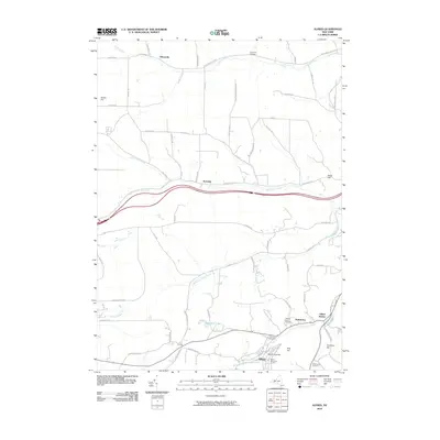
2010 Map of Alfred
USGS Topo · Published 2010About this map
Alfred University dominates the southern portion of this landscape, its campus grounds marked by the Davis Memorial Carillon and situated alongside Canacadea Creek. The village of Alfred is central to a cluster of small settlements, including Tinkertown and Alfred Station, that developed along the valley floor. To the north, the terrain transitions into a network of rural roads such as N Almond Valley Rd and Karr Valley Rd, which follow the natural drainage of the Canisteo River and its tributaries. Several family and community burial grounds, including Lippincott Cemetery and Stillman Cemetery, are scattered across the hillsides, providing valuable points of reference for genealogists. The map illustrates a community defined by its educational center and the winding stream valleys that dictate the placement of its early roads and hamlets like Hiltonville and Karrdale.
Find a feature on this map
70 named features on this map. Tap any name to fly to it.
Don’t see what you’re looking for? This feature index may not catch every label — zoom into the map to look around manually.
Map Details
Editions of this 2010 Alfred Map
This is the sole edition of this map. No revisions or reprints were ever made.
Other maps of this area

1915 · Hornell
USGS Topo · 1:62,500

1916 · Canaseraga
USGS Topo · 1:62,500

1918 · Hornell
USGS Topo · 1:62,500

1926 · Wellsville
USGS Topo · 1:62,500

1926 · Greenwood
USGS Topo · 1:62,500

1940 · Canaseraga
USGS Topo · 1:62,500

1950 · Elmira
USGS Topo · 1:250,000

1958 · Elmira
USGS Topo · 1:250,000

1962 · Elmira
USGS Topo · 1:250,000
1964 · Alfred
USGS Topo · 1:24,000