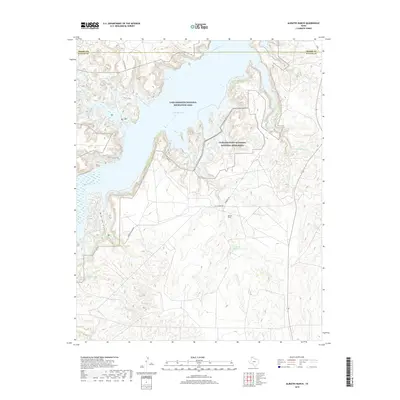
2019 Map of Alibates Ranch
USGS Topo · Published 2019About this map
The Canadian River cuts through the high plains of the Texas Panhandle, creating a complex landscape of drainages and mesas in Potter County. This area is dominated by the Lake Meredith National Recreation Area, where the dammed waters of the river fill deep canyons like Mcbride Canyon. The geography reflects a long history of human presence, from the ancient stone resources protected at the Alibates Flint Quarries National Monument to the namesake Alibates Ranch. Significant tributaries including Plum Creek, Mullinaw Creek, and Alibates Creek carve into the plateau, while the Devils Canyon Trail provides access to the broken terrain overlooking the reservoir. High-plains ranching roads like Cas Johnson Rd and Alibates Rd connect the isolated ranching outposts and recreational sites across this arid landscape.
Find a feature on this map
22 named features on this map. Tap any name to fly to it.
Don’t see what you’re looking for? This feature index may not catch every label — zoom into the map to look around manually.
Map Details
Editions of this 2019 Alibates Ranch Map
This is the sole edition of this map. No revisions or reprints were ever made.
Other maps of this area

1934 · Cliffside
USGS Topo · 1:62,500

1936 · Fourways
USGS Topo · 1:62,500

1936 · Cliffside
USGS Topo · 1:62,500

1939 · Sanford
USGS Topo · 1:62,500

1953 · Sanford
USGS Topo · 1:24,000

1953 · Chunky
USGS Topo · 1:24,000

1953 · Alibates Ranch
USGS Topo · 1:24,000

1953 · Evans Canyon
USGS Topo · 1:24,000

1953 · Deal
USGS Topo · 1:24,000

1953 · McDowell Creek
USGS Topo · 1:24,000