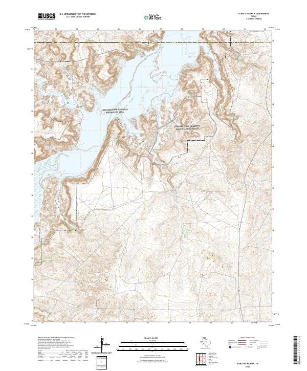
2022 Map of Alibates Ranch
USGS Topo · Published 2022About this map
Alibates Flint Quarries National Monument dominates the eastern high ground of this Potter County landscape, preserving the site where prehistoric peoples gathered colorful agatized dolomite for thousands of years. The western portion of the map is defined by the expanse of Lake Meredith, part of the Lake Meredith National Recreation Area. The topography is deeply incised by numerous drainages including Plum Cr, Mullinaw Cr, and Alibates Cr, which flow toward the reservoir through a network of canyons. Cultural history is traced through rugged access routes like Alibates Rd and the McBride Ranch Road (Rt 212), while natural water sources like Coldwater Spring provide focal points in this arid terrain. The map also delineates the northern boundary shared with Moore County, showing a landscape managed for both geological heritage and modern recreation.
Find a feature on this map
27 named features on this map. Tap any name to fly to it.
Don’t see what you’re looking for? This feature index may not catch every label — zoom into the map to look around manually.
Map Details
Editions of this 2022 Alibates Ranch Map
This is the sole edition of this map. No revisions or reprints were ever made.
Other maps of this area

1934 · Cliffside
USGS Topo · 1:62,500

1936 · Fourways
USGS Topo · 1:62,500

1936 · Cliffside
USGS Topo · 1:62,500

1939 · Sanford
USGS Topo · 1:62,500

1953 · Sanford
USGS Topo · 1:24,000

1953 · Chunky
USGS Topo · 1:24,000

1953 · Alibates Ranch
USGS Topo · 1:24,000

1953 · Evans Canyon
USGS Topo · 1:24,000

1953 · Deal
USGS Topo · 1:24,000

1953 · McDowell Creek
USGS Topo · 1:24,000