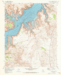
1970 Map of Alibates Ranch
USGS Topo · Published 1973About this map
Lake Meredith dominates the landscape of the Texas Panhandle in this early 1970s survey, representing a significant transformation of the Canadian River valley. The map documents the extensive Lake Meredith Recreation Area at a specific stage of development, including boat access points like Plum Creek Ramp and Bates Ramp. Amidst the modern reservoir infrastructure, the map preserves the location of the McBride Ranch (Historical Site) and the Alibates Ranch, highlighting the transition from traditional ranching to public recreation and resource management.
Find a feature on this map
30 named features on this map. Tap any name to fly to it.
Don’t see what you’re looking for? This feature index may not catch every label — zoom into the map to look around manually.
Map Details
Editions of this 1970 Alibates Ranch Map
This is the sole edition of this map. No revisions or reprints were ever made.
Other maps of this area

1934 · Cliffside
USGS Topo · 1:62,500

1936 · Fourways
USGS Topo · 1:62,500

1936 · Cliffside
USGS Topo · 1:62,500

1939 · Sanford
USGS Topo · 1:62,500

1953 · Sanford
USGS Topo · 1:24,000

1953 · Chunky
USGS Topo · 1:24,000

1953 · Alibates Ranch
USGS Topo · 1:24,000

1953 · Evans Canyon
USGS Topo · 1:24,000

1953 · Deal
USGS Topo · 1:24,000

1953 · McDowell Creek
USGS Topo · 1:24,000