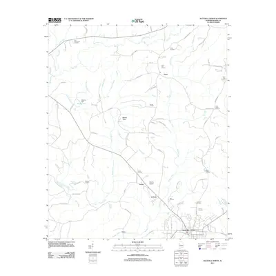
2011 Map of Aliceville North
USGS Topo · Published 2011About this map
Aliceville anchors the southern portion of this Pickens County landscape, which transitions into a grid of rural communities and family cemeteries as it moves north. Small settlements like Garden, McMullen, and Sapps are interconnected by a network of local roads such as Sapps Rd and Garden Church Rd. The terrain is defined by the winding paths of Beaver Creek and Blubber Creek, while Sanders Dam on Sanders Lake serves as a notable water management feature in the west. Genealogists will find a wealth of data points here, with numerous burial sites including Pilgrim Rest Cemetery, Fleming Cemetery, and the Aliceville Memorial Gardens. The northern reaches include Beaver Town and the New Cumberland Cemetery, showing the persistent rural settlement pattern of central Alabama into the early 21st century.
Find a feature on this map
84 named features on this map. Tap any name to fly to it.
Don’t see what you’re looking for? This feature index may not catch every label — zoom into the map to look around manually.
Map Details
Editions of this 2011 Aliceville North Map
This is the sole edition of this map. No revisions or reprints were ever made.
Other maps of this area

1953 · West Point
USGS Topo · 1:250,000

1958 · West Point
USGS Topo · 1:250,000

1960 · Columbus
USGS Topo · 1:62,500

1963 · West Point
USGS Topo · 1:250,000

1966 · Reform SW
USGS Topo · 1:24,000

1967 · Carrollton
USGS Topo · 1:24,000

1970 · Aliceville North
USGS Topo · 1:24,000
1970 · Cunningham
USGS Topo · 1:24,000
1970 · Pleasant Ridge
USGS Topo · 1:24,000

1970 · Aliceville South
USGS Topo · 1:24,000