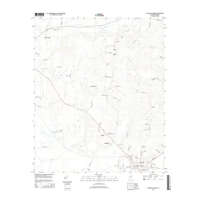
2014 Map of Aliceville North
USGS Topo · Published 2014About this map
Aliceville anchors the southeastern corner of this west Alabama landscape, where the town grid meets the winding courses of Blubber Cr and Beaver Cr. This 2014 survey records a network of rural settlements including Sapps, Beaver Town, Garden, and McMullen, many of which are situated along the Al-14 corridor. The geography is heavily defined by family and community history, evidenced by a high density of small cemeteries such as New Cumberland Cem near Pickensville and Pilgrim Rest Cem further east. The transition from the more developed streets of the county seat toward the west and north reveals a pattern of scattered homesteads and timbered tracts, punctuated by landmarks like Sanders Lake and Aliceville Memorial Gardens. Notable water features like Big Cr and Little Cr flow through the northern reaches, supporting the agricultural character that has defined Pickens County for generations.
Find a feature on this map
86 named features on this map. Tap any name to fly to it.
Don’t see what you’re looking for? This feature index may not catch every label — zoom into the map to look around manually.
Map Details
Editions of this 2014 Aliceville North Map
This is the sole edition of this map. No revisions or reprints were ever made.
Other maps of this area

1953 · West Point
USGS Topo · 1:250,000

1958 · West Point
USGS Topo · 1:250,000

1960 · Columbus
USGS Topo · 1:62,500

1963 · West Point
USGS Topo · 1:250,000

1966 · Reform SW
USGS Topo · 1:24,000

1967 · Carrollton
USGS Topo · 1:24,000

1970 · Aliceville North
USGS Topo · 1:24,000
1970 · Cunningham
USGS Topo · 1:24,000
1970 · Pleasant Ridge
USGS Topo · 1:24,000

1970 · Aliceville South
USGS Topo · 1:24,000