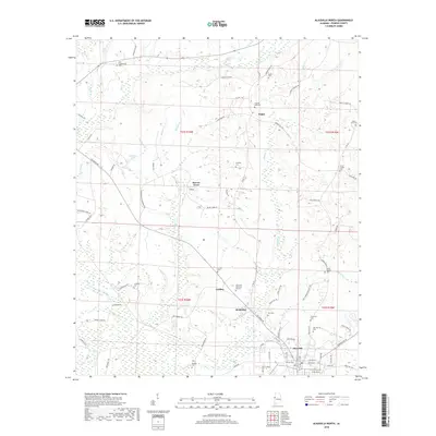
2018 Map of Aliceville North
USGS Topo · Published 2018About this map
Aliceville anchors the southern edge of this West Alabama landscape, where the town's northern reaches give way to a network of rural hamlets and family burial grounds. The terrain is defined by the winding paths of Blubber Cr and Beaver Cr, which drain the lowlands between scattered settlements like Sapps, Garden, and McMullen. Local history and genealogy are deeply embedded in the land, evidenced by the high density of cemeteries such as Oak Hill Cem, Pilgrim Rest Cem, and the Aliceville Memorial Gardens. Small-scale infrastructure like Bonner Mill Rd and Columbus Rd connects these communities, while natural features like Sanders Lake and Snake Cr mark the drainage patterns toward the Black Warrior River basin. The map reveals a transition from the structured street grid of the county seat to the unincorporated reaches of Beaver Town, reflecting the long-standing agricultural and residential patterns of Pickens County.
Find a feature on this map
88 named features on this map. Tap any name to fly to it.
Don’t see what you’re looking for? This feature index may not catch every label — zoom into the map to look around manually.
Map Details
Editions of this 2018 Aliceville North Map
This is the sole edition of this map. No revisions or reprints were ever made.
Other maps of this area

1953 · West Point
USGS Topo · 1:250,000

1958 · West Point
USGS Topo · 1:250,000

1960 · Columbus
USGS Topo · 1:62,500

1963 · West Point
USGS Topo · 1:250,000

1966 · Reform SW
USGS Topo · 1:24,000

1967 · Carrollton
USGS Topo · 1:24,000

1970 · Aliceville North
USGS Topo · 1:24,000
1970 · Cunningham
USGS Topo · 1:24,000
1970 · Pleasant Ridge
USGS Topo · 1:24,000

1970 · Aliceville South
USGS Topo · 1:24,000