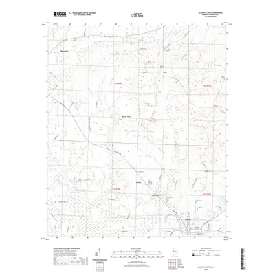
2020 Map of Aliceville North
USGS Topo · Published 2020About this map
Aliceville and its northern surroundings in Pickens County are defined by the winding drainages of Beaver Creek and Blubber Creek, where small rural communities are interconnected by a dense network of country roads. The landscape is dotted with small settlements like Beaver Town, Sapps, and McMullen, each maintaining a distinct identity through local landmarks and historic burial grounds. Genealogists and local historians will find a high density of cemeteries, including Oak Hill Cemetery and New Cemetery near Aliceville, as well as the more remote Mount Sinai Cemetery and Mount Hebron Cemetery. To the northwest, Pickensville sits near the upper reaches of Snake Creek, while the central portion of the map features Sanders Lake and the Aliceville Memorial Gardens. The grid of sections from townships t21s r16w and t22s r16w provides a clear framework for tracing land ownership and the evolution of these western Alabama communities.
Find a feature on this map
91 named features on this map. Tap any name to fly to it.
Don’t see what you’re looking for? This feature index may not catch every label — zoom into the map to look around manually.
Map Details
Editions of this 2020 Aliceville North Map
This is the sole edition of this map. No revisions or reprints were ever made.
Other maps of this area

1953 · West Point
USGS Topo · 1:250,000

1958 · West Point
USGS Topo · 1:250,000

1960 · Columbus
USGS Topo · 1:62,500

1963 · West Point
USGS Topo · 1:250,000

1966 · Reform SW
USGS Topo · 1:24,000

1967 · Carrollton
USGS Topo · 1:24,000

1970 · Aliceville North
USGS Topo · 1:24,000
1970 · Cunningham
USGS Topo · 1:24,000
1970 · Pleasant Ridge
USGS Topo · 1:24,000

1970 · Aliceville South
USGS Topo · 1:24,000