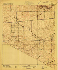
1915 Map of Alief
USGS Topo · Published 1915About this map
The farming community of Alief and the nearby settlement of Jeannetta anchor this 1915 survey of the prairie west of Houston. The landscape is defined by the early transportation corridors of the San Antonio and Aransas Pass and the Missouri Kansas and Texas railroads, which parallel the drainage of Brays Bayou and San Antonio Bayou. Grounded in the work of Chief Geographer R. B. Marshall, the map captures a transition point in local development before suburban expansion, showing a rural network of landmarks like the Riceville Church and Piney Point School. Prominent thoroughfares such as Westheimer Road and Old Richmond Road provide a look at the early road system that would eventually shape the region's growth. To the south, the Harris Co Fort Bend Co line marks the jurisdictional boundary amidst a sparse scatter of farmsteads and bench marks.
Find a feature on this map
22 named features on this map. Tap any name to fly to it.
Don’t see what you’re looking for? This feature index may not catch every label — zoom into the map to look around manually.
Map Details
Editions of this 1915 Alief Map
3 editions found
Other maps of this area

1915 · Bellaire
USGS Topo · 1:24,000

1915 · Houston Heights
USGS Topo · 1:24,000

1915 · Alief
USGS Topo · 1:24,000

1915 · Addicks
USGS Topo · 1:24,000

1915 · Hillendahl
USGS Topo · 1:24,000

1915 · Clodine
USGS Topo · 1:24,000

1918 · Addicks
USGS Topo · 1:31,680

1918 · Hillendahl
USGS Topo · 1:31,680

1919 · Clodine
USGS Topo · 1:31,680

1920 · Almeda
USGS Topo · 1:31,680