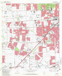
1982 Map of Alief
USGS Topo · Published 1982About this map
Brays Bayou and Keegans Bayou wind through this early 1980s landscape, illustrating the rapid suburbanization extending west from Houston. The map reveals a dense network of educational and religious institutions supporting these emerging communities, including St Agnes Academy, St Francis de Sales Sch, and Alief Brethren Ch. Significant land use is dedicated to sprawling facilities like the Forest Park-Westheimer Cemetery and the Andrau Airpark, a prominent local aviation hub of the era. The industrial and transit pulse of the region is defined by the Southern Pacific railroad corridor, which serves the established hubs of Alief, Stafford, and Sugar Land. While residential tracts expand, large recreational and medical spaces like the Sharpstown Country Club and Houston Baptist University anchor the urban transition.
Find a feature on this map
72 named features on this map. Tap any name to fly to it.
Don’t see what you’re looking for? This feature index may not catch every label — zoom into the map to look around manually.
Map Details
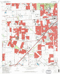
Editions of this 1982 Alief Map
2 editions found
Other maps of this area

1915 · Bellaire
USGS Topo · 1:24,000

1915 · Houston Heights
USGS Topo · 1:24,000

1915 · Alief
USGS Topo · 1:24,000

1915 · Addicks
USGS Topo · 1:24,000

1915 · Hillendahl
USGS Topo · 1:24,000

1915 · Clodine
USGS Topo · 1:24,000

1918 · Addicks
USGS Topo · 1:31,680

1918 · Hillendahl
USGS Topo · 1:31,680

1919 · Clodine
USGS Topo · 1:31,680

1920 · Almeda
USGS Topo · 1:31,680