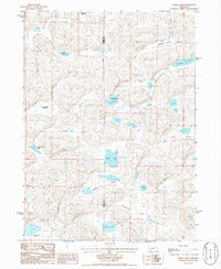
1986 Map of Alkali Lake
USGS Topo · Published 1986About this map
The interdunal basins of the Nebraska Sandhills are on full display in this mid-1980s topographic study, where the boundary between Garden and Grant Counties cuts through a landscape defined by seasonal and permanent water bodies. These "valleys" are not traditional river valleys but rather low-lying pockets between dunes, such as Diamond Valley and Kramer Valley, where groundwater often reaches the surface. Named features like Alkali Lake and Potter Lake highlight the characteristic hydrology of the region, where water alkalinity varies significantly between neighboring basins.
Find a feature on this map
16 named features on this map. Tap any name to fly to it.
Don’t see what you’re looking for? This feature index may not catch every label — zoom into the map to look around manually.
Map Details
Editions of this 1986 Alkali Lake Map
This is the sole edition of this map. No revisions or reprints were ever made.
Other maps of this area

1948 · Ashby
USGS Topo · 1:62,500

1948 · Bingham
USGS Topo · 1:62,500

1948 · George Lake
USGS Topo · 1:62,500

1949 · Ashby
USGS Topo · 1:62,500

1950 · George Lake
USGS Topo · 1:62,500

1950 · Longfellow Lake
USGS Topo · 1:62,500

1950 · Bingham
USGS Topo · 1:62,500

1954 · Scottsbluff
USGS Topo · 1:250,000

1954 · North Platte
USGS Topo · 1:250,000

1955 · Alliance
USGS Topo · 1:250,000