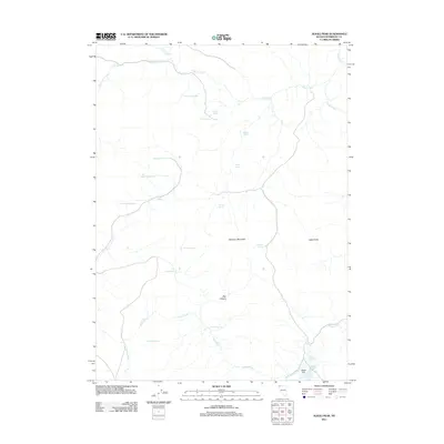
2011 Map of Alkali Peak
USGS Topo · Published 2011About this map
Alkali Peak and Devaney Mountain dominate this remote pocket of Humboldt County, defining a high desert landscape where water is the primary point of interest. This 2011 survey illustrates a complex network of ephemeral drainages and named water sources, vital for navigation and ranching in the Great Basin. Virgin Creek winds through the southern and eastern portions of the quadrangle, eventually reaching the Alkali Reservoir and the expansive Alkali Flat. Numerous springs with distinctive local names, such as Big Buckaroo Spring, Pat Hurd Spring, and McClusky Spring, serve as landmarks across the dry terrain. The topography is further defined by geologic features like The Dip in the north and the steep walls of Box Canyon, reflecting the era's ongoing reliance on these natural features for land management and orientation.
Find a feature on this map
24 named features on this map. Tap any name to fly to it.
Don’t see what you’re looking for? This feature index may not catch every label — zoom into the map to look around manually.
Map Details
Editions of this 2011 Alkali Peak Map
This is the sole edition of this map. No revisions or reprints were ever made.
Other maps of this area

1889 · Long Valley
USGS Topo · 1:250,000

1954 · Vya
USGS Topo · 1:250,000

1958 · Vya
USGS Topo · 1:250,000

1962 · Vya
USGS Topo · 1:250,000

1965 · Rock Spring Table
USGS Topo · 1:62,500

1966 · Big Spring Butte
USGS Topo · 1:62,500

1966 · Blowout Mtn
USGS Topo · 1:24,000

1966 · Badger Mtn SE
USGS Topo · 1:24,000
1966 · Catnip Mtn. SE
USGS Topo · 1:24,000
1987 · Vya
USGS Topo · 1:100,000