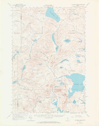
1961 Map of Allagash Lake
USGS Topo · Published 1968About this map
Allagash Lake and Chemquasabamticook Lake dominate this remote northern Maine landscape, characterized by the intricate waterway networks of the North Woods. The region is largely defined by its timber and wilderness infrastructure, showing a transition from traditional water routes to the early logging roads marked as Private or Jeep Trails. Surveyors identified various Camps and a dedicated Forest Service Camp, reflecting the area's management and its role as a destination for sportsmen.
Find a feature on this map
73 named features on this map. Tap any name to fly to it.
Don’t see what you’re looking for? This feature index may not catch every label — zoom into the map to look around manually.
Map Details
Editions of this 1961 Allagash Lake Map
3 editions found

Other maps of this area

1932 · Umsaskis Lake
USGS Topo · 1:48,000

1935 · Umsaskis Lake
USGS Topo · 1:62,500

1954 · Chesuncook
USGS Topo · 1:62,500

1954 · Baker Lake
USGS Topo · 1:62,500

1954 · Caucomgomoc Lake
USGS Topo · 1:62,500

1954 · Churchill Lake
USGS Topo · 1:62,500

1954 · Allagash Lake
USGS Topo · 1:62,500

1954 · St. John Pond
USGS Topo · 1:62,500

1954 · Presque Isle
USGS Topo · 1:250,000

1955 · Beaver Pond
USGS Topo · 1:62,500