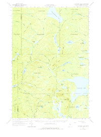
1961 Map of Allagash Lake
USGS Topo · Published 1979About this map
The Somerset and Piscataquis county line divides this remote portion of Northern Maine, where the landscape is defined by the intricate waterways of the Allagash wilderness. Chemquasabamticook Lake dominates the northern border, feeding into a network of brooks and ponds connected by Allagash Stream. The area's management and recreation are evident through a system of private logging roads and named paths such as the Avery Trail, which winds past Allagash Mtn. A Forest Service Camp and a Lookout Tower on the mountain peaks suggest the region's importance for timber monitoring and fire prevention during the early 1960s. Small logging Camps and isolated Gravel Pits are scattered among the ridges, including Maple Ridge and Narrow Ridge, illustrating the working nature of these woods. The presence of numerous family-named water bodies like Wadleigh Pond and Crescent Pond highlights the long-standing local nomenclature used by woodsmen and surveyors in the North Maine Woods.
Find a feature on this map
79 named features on this map. Tap any name to fly to it.
Don’t see what you’re looking for? This feature index may not catch every label — zoom into the map to look around manually.
Map Details
Editions of this 1961 Allagash Lake Map
3 editions found

Other maps of this area

1932 · Umsaskis Lake
USGS Topo · 1:48,000

1935 · Umsaskis Lake
USGS Topo · 1:62,500

1954 · Chesuncook
USGS Topo · 1:62,500

1954 · Baker Lake
USGS Topo · 1:62,500

1954 · Caucomgomoc Lake
USGS Topo · 1:62,500

1954 · Churchill Lake
USGS Topo · 1:62,500

1954 · Allagash Lake
USGS Topo · 1:62,500

1954 · St. John Pond
USGS Topo · 1:62,500

1954 · Presque Isle
USGS Topo · 1:250,000

1955 · Beaver Pond
USGS Topo · 1:62,500