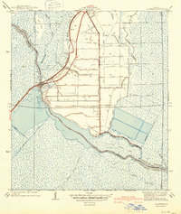
1940 Map of Allemands
USGS Topo · Published 1940About this map
The Southern Pacific railroad corridor anchors this 1938 survey of the marshy transition between St. Charles Parish and Lafourche Parish. Centered on the settlement at Des Allemands Sta, the landscape reveals a rigid system of reclaimed land evidenced by dozens of numbered drainage canals, such as Canal No 24 and Canal No 13, which cut through the cypress swamps to reach Lac des Allemands. Local life is concentrated near the rail line and the St. Charles Sch, while the surrounding waterways like Bayou des Allemands and Bayou Grand Crocodile follow their natural, meandering courses. This interaction between the geometric canal grid and the organic bayous illustrates the early 20th-century efforts to manage the wet Louisiana terrain for transport and settlement.
Find a feature on this map
46 named features on this map. Tap any name to fly to it.
Don’t see what you’re looking for? This feature index may not catch every label — zoom into the map to look around manually.
Map Details
Editions of this 1940 Allemands Map
2 editions found
Other maps of this area

1891 · Hahnville
USGS Topo · 1:62,500

1892 · Lac Des Allemands
USGS Topo · 1:62,500

1892 · Cut-Off
USGS Topo · 1:62,500

1892 · Houma
USGS Topo · 1:62,500

1932 · Lac Des Allemands SE
USGS Topo · 1:31,680

1932 · Houma NE
USGS Topo · 1:31,680

1932 · Hahnville NW
USGS Topo · 1:31,680

1932 · Lac Des Allemands NE
USGS Topo · 1:31,680

1932 · Hahnville SW
USGS Topo · 1:31,680

1932 · Hahnville NE
USGS Topo · 1:31,680