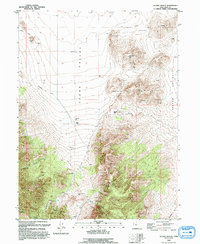
1993 Map of Allens Ranch
USGS Topo · Published 1993About this map
Cedar Valley and Goshen Valley meet in this landscape of high peaks and mining activity, as documented in 1989. The terrain is defined by prominent elevations such as Bismark Peak, Pinyon Peak, and Wanlass Hill, which separate the flat ranch lands from more complex mountain passes. Local industry is clearly visible through the Tintic Paymaster No 2 and the Selma Mine, alongside numerous prospects scattered across the ridges.
Find a feature on this map
29 named features on this map. Tap any name to fly to it.
Don’t see what you’re looking for? This feature index may not catch every label — zoom into the map to look around manually.
Map Details
Editions of this 1993 Allens Ranch Map
This is the sole edition of this map. No revisions or reprints were ever made.
Other maps of this area

1885 · Salt Lake
USGS Topo · 1:250,000

1885 · Manti
USGS Topo · 1:250,000

1885 · Sevier Desert
USGS Topo · 1:250,000

1885 · Tooele Valley
USGS Topo · 1:250,000

1895 · Manti
USGS Topo · 1:250,000

1947 · Fivemile Pass
USGS Topo · 1:62,500

1947 · Allens Ranch
USGS Topo · 1:24,000

1947 · Boulter Peak
USGS Topo · 1:24,000

1947 · Goshen Pass
USGS Topo · 1:24,000

1949 · Eureka
USGS Topo · 1:24,000