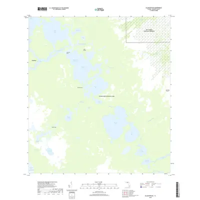
2018 Map of Alligator Bay
USGS Topo · Published 2018About this map
Big Cypress National Preserve and Everglades National Park meet in this 2018 survey, documenting a complex labyrinth of mangrove shorelines and brackish estuaries. The coastal settlement of Chatham sits near the mouth of the Chatham River, serving as a gateway to the intricate Wilderness Waterway. This passage weaves through a series of significant water bodies including Chevelier Bay, Tarpon Bay, and the expansive Alligator Bay. The map captures a landscape defined by tidal influence and low-lying landforms such as Deer Island, Opossum Key, and Gopher Key. Further inland, the hydrology is marked by the Gator Bay Canal and Gator Bay Prairie, illustrating the transition from open Gulf waters to the interior sawgrass and cypress strands. This modern record provides precise data on the shifting banks and named bays like Dads Bay and Lostmans Five Bay that have long challenged navigators of the Florida coast.
Find a feature on this map
38 named features on this map. Tap any name to fly to it.
Don’t see what you’re looking for? This feature index may not catch every label — zoom into the map to look around manually.
Map Details
Editions of this 2018 Alligator Bay Map
This is the sole edition of this map. No revisions or reprints were ever made.
Other maps of this area

1956 · Miami
USGS Topo · 1:250,000

1958 · Miami
USGS Topo · 1:250,000

1972 · Big Boy Lake
USGS Topo · 1:24,000

1973 · Gator Hook Swamp
USGS Topo · 1:24,000

1973 · Pavilion Key
USGS Topo · 1:24,000
1973 · Plover Key
USGS Topo · 1:24,000

1973 · Monroe Station
USGS Topo · 1:24,000

1973 · Big Lostmans Bay
USGS Topo · 1:24,000

1973 · Lostmans River Ranger Station
USGS Topo · 1:24,000

1973 · Alligator Bay
USGS Topo · 1:24,000