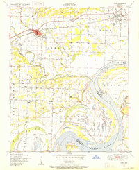
1951 Map of Alma
USGS Topo · Published 1951About this map
Alma and the surrounding Crawford County bottomlands are defined by the winding course of the Arkansas River and its numerous tributaries. In the early post-war era, this region supported a diverse mix of infrastructure, from the Missouri Pacific railroad corridor to the numerous natural gas wells labeled simply as gas scattered across the landscape. The river's influence is evident in the complex drainage patterns of Frog Bayou, House Slough, and the expansive Arbuckle Island, alongside man-made features like the Alma Airfield. Local history is preserved through scattered rural landmarks, including Pleasant Home Church, Woods Cemetery, and an abandoned mine near Mays Branch. The map also captures several smaller communities such as Dyer, Kibler, and Yoestown, providing a detailed look at the agricultural and industrial footprint of the Arkansas River Valley before modern development altered these historic property lines.
Find a feature on this map
42 named features on this map. Tap any name to fly to it.
Don’t see what you’re looking for? This feature index may not catch every label — zoom into the map to look around manually.
Map Details
Editions of this 1951 Alma Map
This is the sole edition of this map. No revisions or reprints were ever made.
Other maps of this area

1879 · Fort Smith
USGS Topo · 1:62,500

1887 · Van Buren
USGS Topo · 1:62,500

1890 · Fort Smith
USGS Topo · 1:125,000

1898 · Winslow #4
USGS Topo · 1:62,500

1898 · Winslow #3
USGS Topo · 1:62,500

1898 · Winslow
USGS Topo · 1:125,000

1901 · Winslow
USGS Topo · 1:125,000

1906 · Lavaca
USGS Topo · 1:62,500

1943 · Fort Smith
USGS Topo · 1:125,000

1946 · Fort Smith
USGS Topo · 1:250,000