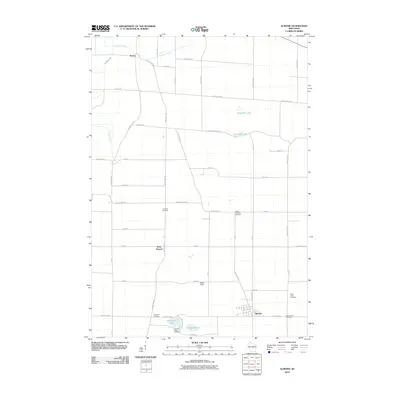
2010 Map of Almond
USGS Topo · Published 2010About this map
Almond sits at the southern edge of this Central Wisconsin landscape, where a dense network of county highways and local roads connects small rural settlements. The area's social history is recorded in its numerous burial grounds, ranging from the Lone Pine Cemetery north of West Almond to the East German Cemetery near the main townsite. This distribution of sites like Saint Johns Cemetery and Spiritland Cemetery suggests a legacy of distinct immigrant communities and localized family plots common to Portage County's development.
Find a feature on this map
46 named features on this map. Tap any name to fly to it.
Don’t see what you’re looking for? This feature index may not catch every label — zoom into the map to look around manually.
Map Details
Editions of this 2010 Almond Map
This is the sole edition of this map. No revisions or reprints were ever made.
Other maps of this area

1955 · Green Bay
USGS Topo · 1:250,000

1957 · Amherst
USGS Topo · 1:48,000

1957 · Whiting
USGS Topo · 1:48,000

1958 · Coloma
USGS Topo · 1:48,000

1959 · Wautoma
USGS Topo · 1:48,000

1968 · Plainfield
USGS Topo · 1:24,000

1968 · Hancock
USGS Topo · 1:24,000
1968 · Wautoma NE
USGS Topo · 1:24,000
1969 · Blaine
USGS Topo · 1:24,000

1969 · Arnott
USGS Topo · 1:24,000