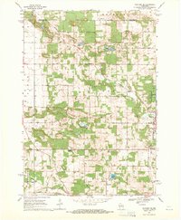
1968 Map of Wautoma NE
USGS Topo · Published 1971About this map
The village of Wild Rose sits along the Chicago and North Western railway in this late 1960s study of central Wisconsin. This portion of Waushara County is defined by a dense network of country roads like Akron Drive and Apache Drive that weave through a glacial landscape dotted with small kettle lakes. Local history is anchored by several rural burying grounds, including Bohemian Cem and Staples Cem, which served the farming communities across the townships of Rose and Oasis.
Find a feature on this map
38 named features on this map. Tap any name to fly to it.
Don’t see what you’re looking for? This feature index may not catch every label — zoom into the map to look around manually.
Map Details
Editions of this 1968 Wautoma NE Map
2 editions found
Other maps of this area

1955 · Green Bay
USGS Topo · 1:250,000

1957 · Amherst
USGS Topo · 1:48,000

1957 · Waupaca
USGS Topo · 1:48,000

1959 · Wautoma
USGS Topo · 1:48,000

1961 · Redgranite
USGS Topo · 1:62,500

1961 · Wild Rose
USGS Topo · 1:24,000

1961 · Spring Lake
USGS Topo · 1:24,000

1968 · Richford
USGS Topo · 1:24,000

1968 · Plainfield
USGS Topo · 1:24,000
1968 · Wautoma
USGS Topo · 1:24,000