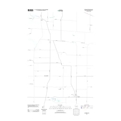
2013 Map of Almond
USGS Topo · Published 2013About this map
The settlement of Almond anchors the southeastern corner of this Portage County landscape, where the agricultural grid is defined by a network of well-maintained county highways and local roads. To the west, the smaller community of West Almond sits at the junction of Co Hwy-BB and 3rd Ave, while Keene marks the northern extent of the quadrangle. The terrain is notably water-influenced, featuring several distinct glacial kettle lakes such as Patterson Lake, Tamarack Lake, and Washburn Lake. In the northern sections, drainage is managed through an engineered system of waterways including Ditch Number Three and Ditch Number Eight. The inclusion of Swan Field Airport south of 2nd Ave highlights the modern rural utility of the region, where flat plains support both traditional farming and small-scale aviation infrastructure.
Find a feature on this map
47 named features on this map. Tap any name to fly to it.
Don’t see what you’re looking for? This feature index may not catch every label — zoom into the map to look around manually.
Map Details
Editions of this 2013 Almond Map
This is the sole edition of this map. No revisions or reprints were ever made.
Other maps of this area

1955 · Green Bay
USGS Topo · 1:250,000

1957 · Amherst
USGS Topo · 1:48,000

1957 · Whiting
USGS Topo · 1:48,000

1958 · Coloma
USGS Topo · 1:48,000

1959 · Wautoma
USGS Topo · 1:48,000

1968 · Plainfield
USGS Topo · 1:24,000

1968 · Hancock
USGS Topo · 1:24,000
1968 · Wautoma NE
USGS Topo · 1:24,000
1969 · Blaine
USGS Topo · 1:24,000

1969 · Arnott
USGS Topo · 1:24,000