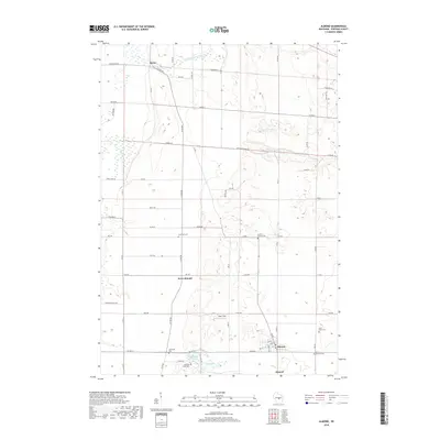
2018 Map of Almond
USGS Topo · Published 2018About this map
Almond and its surrounding rural township are defined by a rhythmic landscape of small lakes and agricultural tracts in the late 2010s. The settlement of Keene sits near the northern boundary, while West Almond marks a central crossroads, illustrating the dispersed residential patterns typical of this portion of Portage County. The survey identifies numerous community landmarks including Swan Field and several small water bodies such as Tamarack Lake, Patterson Lake, and Washburn Lake.
Find a feature on this map
56 named features on this map. Tap any name to fly to it.
Don’t see what you’re looking for? This feature index may not catch every label — zoom into the map to look around manually.
Map Details
Editions of this 2018 Almond Map
This is the sole edition of this map. No revisions or reprints were ever made.
Other maps of this area

1955 · Green Bay
USGS Topo · 1:250,000

1957 · Amherst
USGS Topo · 1:48,000

1957 · Whiting
USGS Topo · 1:48,000

1958 · Coloma
USGS Topo · 1:48,000

1959 · Wautoma
USGS Topo · 1:48,000

1968 · Plainfield
USGS Topo · 1:24,000

1968 · Hancock
USGS Topo · 1:24,000
1968 · Wautoma NE
USGS Topo · 1:24,000
1969 · Blaine
USGS Topo · 1:24,000

1969 · Arnott
USGS Topo · 1:24,000