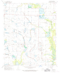
1968 Map of Almyra
USGS Topo · Published 1969About this map
Almyra serves as the focal point of this Arkansas Grand Prairie survey, situated within a landscape defined by advanced water management and agricultural research in the late 1960s. The presence of the Agricultural Experiment Station and an Experimental Fish Farm highlights the region's role in specialized farming, while the St Louis Southwestern railroad and several private landing strips indicate the transport infrastructure supporting this economy. Family history is well-represented through namesake burial sites like Yoder Cem, Almyra Cem, and Coffield Cem, alongside smaller settlements such as Yoder and Holdridge. The terrain is interlaced with irrigation and drainage features including Fish Lake Ditch and Wildcat Ditch, which manage the flow toward Little LaGrue Bayou and Mill Bayou, illustrating the intensive modification of the local hydrology for rice or aquaculture.
Find a feature on this map
25 named features on this map. Tap any name to fly to it.
Don’t see what you’re looking for? This feature index may not catch every label — zoom into the map to look around manually.
Map Details
Editions of this 1968 Almyra Map
This is the sole edition of this map. No revisions or reprints were ever made.
Other maps of this area

1935 · Clarendon
USGS Topo · 1:62,500

1937 · Stuttgart
USGS Topo · 1:62,500

1939 · Stuttgart
USGS Topo · 1:62,500

1941 · De Witt
USGS Topo · 1:62,500

1941 · Goldman
USGS Topo · 1:62,500

1941 · Clarendon
USGS Topo · 1:62,500

1948 · Helena
USGS Topo · 1:250,000

1950 · Helena
USGS Topo · 1:250,000

1954 · De Witt
USGS Topo · 1:62,500

1955 · Helena
USGS Topo · 1:250,000