
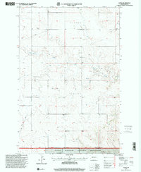
1980 Map of Alpha
USGS Topo · Published 1980About this map
Alpha sits at the heart of this Western North Dakota landscape, straddling the border between Golden Valley and Slope counties. The settlement pattern reflects the open ranching and farming character of the era, punctuated by essential infrastructure like the Randalash Sch and a local Cem. The drainage of Bullion Creek carves through the distinct plateaus of Garner, Lone Tree, and Bullion, while numerous entries for Well and Flowing Well underscore the critical importance of water management in this arid environment. A solitary Landing Strip near the northern edge suggest the vast distances involved in travel and logistics during the late twentieth century. This survey, based on 1973 photography, documents a network of fence lines and improved roads that define the rural economy before modern expansion.
Find a feature on this map
14 named features on this map. Tap any name to fly to it.
Don’t see what you’re looking for? This feature index may not catch every label — zoom into the map to look around manually.
Map Details
Editions of this 1980 Alpha Map
This is the sole edition of this map. No revisions or reprints were ever made.
Other maps of this area

1953 · Dickinson
USGS Topo · 1:250,000

1957 · Dickinson
USGS Topo · 1:250,000

1979 · Sentinel Butte SE
USGS Topo · 1:24,000

1979 · Three V Crossing
USGS Topo · 1:24,000

1979 · Square Butte
USGS Topo · 1:24,000

1980 · Golva
USGS Topo · 1:24,000

1980 · Spring Creek
USGS Topo · 1:24,000

1980 · Thelan
USGS Topo · 1:24,000

1980 · Belfield
USGS Topo · 1:100,000
1997 · Alpha
USGS Topo · 1:24,000