1980 Map of Belfield
USGS Topo · Published 1981About this map
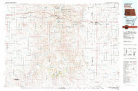
The Little Missouri River carves a path through the heart of this North Dakota landscape, where the badlands terrain meets the vast Little Missouri National Grassland. The map illustrates a region defined by its conservation areas and early industrial footprint, notably the Theodore Roosevelt National Park (South Unit) and the Theodore Roosevelt Wilderness. Cultural history is anchored at Medora near the Chateau de Mores, while the economic activity of the early 1980s is visible through the Fryburg Oil Field and several coal operations including Karsky Mine and Walters Mine.
Find a feature on this map
84 named features on this map. Tap any name to fly to it.
Don’t see what you’re looking for? This feature index may not catch every label — zoom into the map to look around manually.
Map Details
Editions of this 1980 Belfield Map
This is the sole edition of this map. No revisions or reprints were ever made.
Other maps of this area

1909 · Glendive
USGS Topo · 1:250,000

1953 · Miles City
USGS Topo · 1:250,000

1953 · Dickinson
USGS Topo · 1:250,000

1953 · Watford City
USGS Topo · 1:250,000

1954 · Glendive
USGS Topo · 1:250,000

1957 · Dickinson
USGS Topo · 1:250,000

1957 · Miles City
USGS Topo · 1:250,000

1957 · Glendive
USGS Topo · 1:250,000

1957 · Watford City
USGS Topo · 1:250,000

1958 · Miles City
USGS Topo · 1:250,000