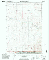
1997 Map of Alpha
USGS Topo · Published 2001About this map
Alpha sits at the heart of this Badlands landscape, surrounded by the high plateau terrain of Bullion, Garner, and Lone Tree. The map captures a sparsely populated region of the Little Missouri National Grassland where the economy is defined by expansive ranching and energy infrastructure. Local historical markers include the Randash Sch and a small Cem near the settlement of Alpha, providing essential waypoints for genealogists tracking family ties to these prairie homesteads. Further south, the Remillong Ranch remains a notable landmark near the drainage of Bullion Creek. The map also traces the path of a significant Pipeline and Pipeline Road traversing the northern sections, reflecting the modern industrial layers superimposed over the traditional grazing lands of the high plains.
Find a feature on this map
14 named features on this map. Tap any name to fly to it.
Don’t see what you’re looking for? This feature index may not catch every label — zoom into the map to look around manually.
Map Details
Editions of this 1997 Alpha Map
This is the sole edition of this map. No revisions or reprints were ever made.
Other maps of this area

1953 · Dickinson
USGS Topo · 1:250,000

1957 · Dickinson
USGS Topo · 1:250,000

1979 · Sentinel Butte SE
USGS Topo · 1:24,000

1979 · Three V Crossing
USGS Topo · 1:24,000

1979 · Square Butte
USGS Topo · 1:24,000

1980 · Golva
USGS Topo · 1:24,000

1980 · Spring Creek
USGS Topo · 1:24,000

1980 · Thelan
USGS Topo · 1:24,000

1980 · Alpha
USGS Topo · 1:24,000

1980 · Belfield
USGS Topo · 1:100,000