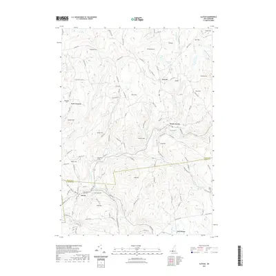
2021 Map of Alstead
USGS Topo · Published 2021About this map
Alstead and the village of Acworth anchor this 2021 topographic perspective of southwestern New Hampshire, where the Sullivan Co Cheshire Co border divides the landscape. The Cold River meanders through the central valley, passing the historic McDermott Bridge and the recreational area at Vilas Pool. This modern survey reveals a region defined by its rugged uplands and narrow river bottoms, with numerous family-named peaks like Grout Hill, Cobb Hill, and Beryl Mtn rising sharply above the valley floor. The map details a network of rural routes, including Old Stage Rd and Old School House Rd, which reflect the area's agricultural and educational heritage. Researchers can find distinct clusters of settlement at South Acworth and East Alstead, while more remote locales like Lynn and South Hemlock persist among the wooded slopes and brooks of the Sullivan Co Cheshire Co highlands.
Find a feature on this map
118 named features on this map. Tap any name to fly to it.
Don’t see what you’re looking for? This feature index may not catch every label — zoom into the map to look around manually.
Map Details
Editions of this 2021 Alstead Map
This is the sole edition of this map. No revisions or reprints were ever made.
Other maps of this area

1902 · Sunapee
USGS Topo · 1:62,500

1905 · Sunapee
USGS Topo · 1:62,500

1907 · Sunapee
USGS Topo · 1:62,500

1926 · Claremont
USGS Topo · 1:62,500

1927 · Bellows Falls
USGS Topo · 1:48,000

1929 · Claremont
USGS Topo · 1:62,500

1930 · Lovewell Mountain
USGS Topo · 1:62,500

1930 · Bellows Falls
USGS Topo · 1:62,500

1942 · Lovewell Mountain
USGS Topo · 1:62,500

1950 · Glens Falls
USGS Topo · 1:250,000