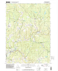
1998 Map of Alstead
USGS Topo · Published 2002About this map
Cold River carves a deep valley through this corner of the Monadnock Region, anchoring the historic centers of Alstead and South Acworth. The landscape is defined by its early industrial and recreational sites, such as the Bell Tower and the local recreation spot at Vilas Pool. Evidence of the area's timber and agricultural roots is visible in the network of town roads like Old Charlestown Road and Old Settlers Road, which connect small hamlets such as Lynn and Five Points. Distinctive landmarks such as the Covered Bridge and Beryl Mtn offer reference points for the local topography, while the eastern edge of the quadrangle is largely occupied by the Feuer State Forest. This survey captures the rural character of Sullivan and Cheshire Counties just before the turn of the millennium, documenting a terrain of granite ledges and upland ponds like Arch Pond and Mitchell Pond.
Find a feature on this map
67 named features on this map. Tap any name to fly to it.
Don’t see what you’re looking for? This feature index may not catch every label — zoom into the map to look around manually.
Map Details
Editions of this 1998 Alstead Map
This is the sole edition of this map. No revisions or reprints were ever made.
Other maps of this area

1902 · Sunapee
USGS Topo · 1:62,500

1905 · Sunapee
USGS Topo · 1:62,500

1907 · Sunapee
USGS Topo · 1:62,500

1926 · Claremont
USGS Topo · 1:62,500

1927 · Bellows Falls
USGS Topo · 1:48,000

1929 · Claremont
USGS Topo · 1:62,500

1930 · Lovewell Mountain
USGS Topo · 1:62,500

1930 · Bellows Falls
USGS Topo · 1:62,500

1942 · Lovewell Mountain
USGS Topo · 1:62,500

1950 · Glens Falls
USGS Topo · 1:250,000