
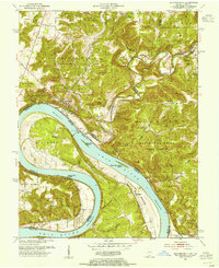
1950 Map of Alton
USGS Topo · Published 1962About this map
The Ohio River winds through a complex boundary landscape where Indiana and Kentucky meet, defining the life and movement of mid-century river towns. Near the sharp river bends, the community of Alton sits at the mouth of the Little Blue River, while the Boyer Ferry across Bear Creek indicates the essential water-based transit of the era. The terrain is deeply incised by drainages like Watson Run and Little Oil Creek, creating a series of hollows and bottoms that dictated the placement of early homesteads and social centers.
Find a feature on this map
41 named features on this map. Tap any name to fly to it.
Don’t see what you’re looking for? This feature index may not catch every label — zoom into the map to look around manually.
Map Details
Editions of this 1950 Alton Map
This is the sole edition of this map. No revisions or reprints were ever made.
Other maps of this area

1928 · Hardinsburg
USGS Topo · 1:48,000

1931 · Hardinsburg
USGS Topo · 1:62,500

1934 · Cannelton
USGS Topo · 1:62,500

1946 · Leavenworth
USGS Topo · 1:24,000

1947 · Irvington
USGS Topo · 1:24,000

1947 · Lodiburg
USGS Topo · 1:24,000

1947 · Leavenworth
USGS Topo · 1:24,000

1947 · Hardinsburg
USGS Topo · 1:62,500

1950 · Beechwood
USGS Topo · 1:24,000
1950 · Leavenworth
USGS Topo · 1:24,000