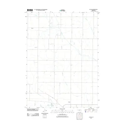
2011 Map of Altona
USGS Topo · Published 2011About this map
Altona sits at the northwest corner of this agricultural landscape, defined by a dense grid of section roads and the meandering path of Plum Creek. The geography here is marked by drainage and irrigation features, including the long stretch of Dry Ditch and the convergence of Kane Creek and Sand Creek. For genealogists and local historians, the Norwegian Cemetery provides a specific point of interest in the southern portion of the quadrangle. The map illustrates a strictly rural economy, where transportation is dictated by a systematic road network such as 848th Rd and 577th Ave, supporting the scattered homesteads and farming operations of eastern Nebraska in the early 21st century.
Find a feature on this map
33 named features on this map. Tap any name to fly to it.
Don’t see what you’re looking for? This feature index may not catch every label — zoom into the map to look around manually.
Map Details
Editions of this 2011 Altona Map
This is the sole edition of this map. No revisions or reprints were ever made.
Other maps of this area

1955 · Sioux City
USGS Topo · 1:250,000

1955 · Fremont
USGS Topo · 1:250,000

1957 · Fremont
USGS Topo · 1:250,000

1958 · Sioux City
USGS Topo · 1:250,000

1958 · Fremont
USGS Topo · 1:250,000

1959 · Sioux City
USGS Topo · 1:250,000

1963 · Pilger
USGS Topo · 1:24,000

1963 · Wisner
USGS Topo · 1:24,000

1963 · Altona
USGS Topo · 1:24,000
1963 · Stanton NE
USGS Topo · 1:24,000