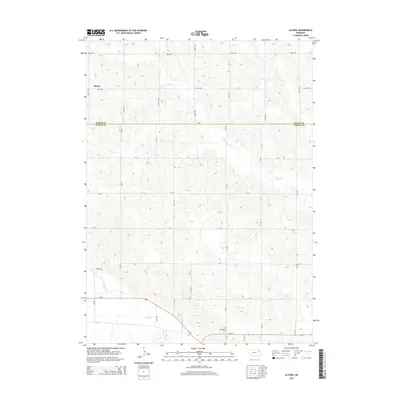
2014 Map of Altona
USGS Topo · Published 2014About this map
The small settlement of Altona sits near the northern boundary of Cuming County, marking a landscape defined by the agricultural grid and the winding paths of local waterways. This 2014 survey documents the area as it straddles the line between Wayne and Cuming counties, where the drainage of Plum Cr and Kane Cr shapes the northern terrain. To the south, the transit corridor of Us-275 and Ne-51 provides the primary infrastructure for the region, crossing over Sand Cr and the functional engineering of Dry Ditch. A notable point of local interest for genealogists and historians is the Norwegian Cem, which stands as a quiet marker of the ethnic heritage and early settlement patterns of this corner of Nebraska. The map reveals how the modern road network, including numerous rural routes like 848th RD and V RD, has been meticulously laid over the natural drainage basins.
Find a feature on this map
19 named features on this map. Tap any name to fly to it.
Don’t see what you’re looking for? This feature index may not catch every label — zoom into the map to look around manually.
Map Details
Editions of this 2014 Altona Map
This is the sole edition of this map. No revisions or reprints were ever made.
Other maps of this area

1955 · Sioux City
USGS Topo · 1:250,000

1955 · Fremont
USGS Topo · 1:250,000

1957 · Fremont
USGS Topo · 1:250,000

1958 · Sioux City
USGS Topo · 1:250,000

1958 · Fremont
USGS Topo · 1:250,000

1959 · Sioux City
USGS Topo · 1:250,000

1963 · Pilger
USGS Topo · 1:24,000

1963 · Wisner
USGS Topo · 1:24,000

1963 · Altona
USGS Topo · 1:24,000
1963 · Stanton NE
USGS Topo · 1:24,000