
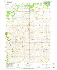
1963 Map of Altona
USGS Topo · Published 1964About this map
Altona sits at the northern edge of this rural landscape, which is defined by the meandering courses of Plum Creek and Sand Creek. The territory, spanning portions of Blaine, Grant, and Leslie townships, reflects a highly organized 1960s agrarian layout with a one-room schoolhouse nearly every few miles, including School No 40 and School No 24. At the southern margin, the Chicago and North Western railroad cuts across the terrain, paralleling a localized cluster of industry marked by Gravel Pits and the nearby Norwegian Cem. This survey illustrates a transitional period in eastern Nebraska's infrastructure, where traditional township centers like Townhall and numerous rural schools remained prominent landmarks even as modern features like a Landing Strip began to appear in the fields.
Find a feature on this map
24 named features on this map. Tap any name to fly to it.
Don’t see what you’re looking for? This feature index may not catch every label — zoom into the map to look around manually.
Map Details
Editions of this 1963 Altona Map
This is the sole edition of this map. No revisions or reprints were ever made.
Other maps of this area

1955 · Sioux City
USGS Topo · 1:250,000

1955 · Fremont
USGS Topo · 1:250,000

1957 · Fremont
USGS Topo · 1:250,000

1958 · Sioux City
USGS Topo · 1:250,000

1958 · Fremont
USGS Topo · 1:250,000

1959 · Sioux City
USGS Topo · 1:250,000

1963 · Pilger
USGS Topo · 1:24,000

1963 · Wisner
USGS Topo · 1:24,000
1963 · Stanton NE
USGS Topo · 1:24,000

1963 · Wayne
USGS Topo · 1:24,000