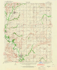
1938 Map of Altoona
USGS Topo · Published 1966About this map
The Altoona region of Wilson County is defined by its early 20th-century agrarian density, where a remarkably tight network of country schoolhouses and small-town junctions reflects a pre-modern rural infrastructure. Located at a bend in the Verdigris River, Altoona serves as a hub alongside neighbors like Buffalo, Benedict, and Vilas. The landscape is etched with the presence of the Missouri Pacific and Santa Fe railroads, which facilitated the local economy of this era. Genealogists will find significant value in the numerous small educational and religious centers, such as Ninety Nine Sch, Sorghum Valley Sch, and High Prairie Ch. Topographically, the area is punctuated by distinct high points like Long Mound and Three Mounds, while the Barnhill Bridge provides a specific reference point for crossing the river valley.
Find a feature on this map
83 named features on this map. Tap any name to fly to it.
Don’t see what you’re looking for? This feature index may not catch every label — zoom into the map to look around manually.
Map Details
Editions of this 1938 Altoona Map
This is the sole edition of this map. No revisions or reprints were ever made.
Other maps of this area

1886 · Fredonia
USGS Topo · 1:125,000

1886 · Iola
USGS Topo · 1:125,000

1886 · Independence
USGS Topo · 1:125,000

1886 · Parsons
USGS Topo · 1:125,000
1893 · Iola
USGS Topo · 1:125,000

1893 · Parsons
USGS Topo · 1:125,000

1894 · Fredonia
USGS Topo · 1:125,000

1894 · Independence
USGS Topo · 1:125,000

1904 · Iola
USGS Topo · 1:125,000

1905 · Independence
USGS Topo · 1:125,000