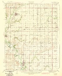
1943 Map of Altoona
USGS Topo · Published 1943About this map
Altoona and Buffalo serve as the primary hubs in this Wilson County landscape, where the Verdigris River and its tributaries dictate the layout of rural life. Surveyed in the late 1930s, the map reveals a dense network of country schools and small churches that anchored these farming communities before mid-century consolidation. Named schools like Ninety Nine Sch, Sorghum Valley Sch, and Baker Valley Sch appear at nearly every section interval, highlighting the localized nature of education at the time.
Find a feature on this map
80 named features on this map. Tap any name to fly to it.
Don’t see what you’re looking for? This feature index may not catch every label — zoom into the map to look around manually.
Map Details
Editions of this 1943 Altoona Map
2 editions found

Other maps of this area

1886 · Fredonia
USGS Topo · 1:125,000

1886 · Iola
USGS Topo · 1:125,000

1886 · Independence
USGS Topo · 1:125,000

1886 · Parsons
USGS Topo · 1:125,000

1893 · Iola
USGS Topo · 1:125,000

1893 · Parsons
USGS Topo · 1:125,000

1894 · Fredonia
USGS Topo · 1:125,000

1894 · Independence
USGS Topo · 1:125,000

1904 · Iola
USGS Topo · 1:125,000

1905 · Independence
USGS Topo · 1:125,000