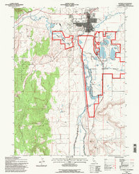
1993 Map of Alturas
USGS Topo · Published 1997About this map
Alturas serves as the focal point of this high-desert plateau region, situated where the North Fork and South Fork of the Pit River converge. The landscape is defined by its sophisticated water management system, featuring an extensive network of levees including the Westside Road on Levee and Eastside Road on Levee that protect the lowlands. Large portions of the valley floor are dedicated to the Modoc National Wildlife Refuge, where numerous springs and weirs regulate the marshy terrain between volcanic landmarks like The Hat and The Three Sisters. The town's social infrastructure is well-established with three educational institutions—Modoc High Sch, Modoc Jr High Sch, and Warner High Sch—alongside the Alturas Rancheria and the rail-oriented Lakeview Junction. This map provides a detailed view of a rural county seat balancing its agricultural requirements with federal conservation efforts.
Find a feature on this map
34 named features on this map. Tap any name to fly to it.
Don’t see what you’re looking for? This feature index may not catch every label — zoom into the map to look around manually.
Map Details
Editions of this 1993 Alturas Map
This is the sole edition of this map. No revisions or reprints were ever made.
Other maps of this area

1886 · Alturas
USGS Topo · 1:250,000

1892 · Alturas
USGS Topo · 1:250,000

1954 · Alturas
USGS Topo · 1:250,000

1958 · Alturas
USGS Topo · 1:250,000

1961 · Alturas
USGS Topo · 1:62,500

1962 · Alturas
USGS Topo · 1:250,000

1962 · Davis Creek
USGS Topo · 1:62,500

1962 · Big Sage Reservoir
USGS Topo · 1:62,500

1963 · Little Juniper Reservoir
USGS Topo · 1:24,000

1963 · Dorris Reservoir
USGS Topo · 1:24,000