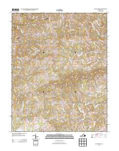
2013 Map of Alum Ridge
USGS Topo · Published 2013About this map
Wangle Junction and Alum Ridge anchor this portrait of Floyd County, Virginia, where the landscape is defined by the high divides of Wills Ridge and the winding tributaries of the Little River. In the early 21st century, the area maintains a rural character dominated by small family settlements and farmsteads such as Duncan Farm and Laurel Branch. This map documents a transition in local transportation and land use, showing the presence of private airfields like Deer Run Airport and Alum Ridge Airport alongside older thoroughfares such as Old State Hwy 8. The drainage pattern is particularly intricate, with Big Indian Cr and the W Fork Little River carving through the plateau, reflecting the traditional reliance on these waterways for early settlement boundaries and mountain agriculture.
Find a feature on this map
93 named features on this map. Tap any name to fly to it.
Don’t see what you’re looking for? This feature index may not catch every label — zoom into the map to look around manually.
Map Details
Editions of this 2013 Alum Ridge Map
This is the sole edition of this map. No revisions or reprints were ever made.
Other maps of this area

1889 · Hillsville
USGS Topo · 1:125,000

1890 · Dublin
USGS Topo · 1:125,000

1890 · Christiansburg
USGS Topo · 1:125,000

1891 · Dublin
USGS Topo · 1:125,000

1892 · Hillsville
USGS Topo · 1:125,000

1896 · Hillsville
USGS Topo · 1:125,000

1932 · Blacksburg
USGS Topo · 1:48,000

1937 · Blacksburg
USGS Topo · 1:62,500

1950 · Radford
USGS Topo · 1:62,500

1953 · Winston-Salem
USGS Topo · 1:250,000