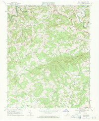
1968 Map of Alum Ridge
USGS Topo · Published 1971About this map
Little River winds through the northern reaches of this Virginia landscape, marking a deeply dissected terrain of ridges and creek valleys late in the 1960s. The settlement pattern is defined by small, upland communities such as Alum Ridge and Carthage, where social life centered on numerous country churches including Alum Ridge Ch and Pleasant Valley Ch. The map reveals a high density of rural cemeteries and family-named landmarks, like Sowers Cem and Wangle Junction, which offer significant value for genealogical research. The prominence of Wills Ridge dominates the central topography, influencing the flow of several drainages like Beaver Creek and Spurlock Creek. This survey captures the region just before the expansion of modern road networks significantly altered these traditional Appalachian community boundaries.
Find a feature on this map
33 named features on this map. Tap any name to fly to it.
Don’t see what you’re looking for? This feature index may not catch every label — zoom into the map to look around manually.
Map Details
Editions of this 1968 Alum Ridge Map
This is the sole edition of this map. No revisions or reprints were ever made.
Other maps of this area

1889 · Hillsville
USGS Topo · 1:125,000

1890 · Dublin
USGS Topo · 1:125,000

1890 · Christiansburg
USGS Topo · 1:125,000

1891 · Dublin
USGS Topo · 1:125,000

1892 · Hillsville
USGS Topo · 1:125,000

1896 · Hillsville
USGS Topo · 1:125,000

1932 · Blacksburg
USGS Topo · 1:48,000

1937 · Blacksburg
USGS Topo · 1:62,500

1950 · Radford
USGS Topo · 1:62,500

1953 · Winston-Salem
USGS Topo · 1:250,000