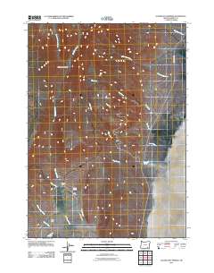
2011 Map of Alvord Hot Springs
USGS Topo · Published 2011About this map
Alvord Hot Springs serves as a focal point in this high-desert landscape of eastern Oregon, where thermal waters emerge near the base of the mountains. The settlement pattern is defined by isolated outposts like Carlson Ranch and Deppy Ranch, highlighting the historical reliance on perennial water sources in an arid environment. A network of drainages, including Indian Creek, Pike Creek, and Tuffy Creek, flows toward the eastern basin, carving sharp relief into the terrain at Wildhorse Canyon. Infrastructure is sparse, anchored by the Fields-Denio Rd and the unpaved Wild Horse Rd, which provide the primary access to these remote ranching and geothermal sites. The presence of Belzar Spring and various creek systems like Stonehouse Creek further emphasizes the critical role of hydrology in shaping human activity and land use in this part of Harney County.
Find a feature on this map
20 named features on this map. Tap any name to fly to it.
Don’t see what you’re looking for? This feature index may not catch every label — zoom into the map to look around manually.
Map Details
Editions of this 2011 Alvord Hot Springs Map
This is the sole edition of this map. No revisions or reprints were ever made.
Other maps of this area

1955 · Adel
USGS Topo · 1:250,000

1957 · Adel
USGS Topo · 1:250,000

1958 · Adel
USGS Topo · 1:250,000

1962 · Adel
USGS Topo · 1:250,000

1968 · Fish Lake
USGS Topo · 1:24,000

1968 · Wildhorse Lake
USGS Topo · 1:24,000

1968 · Alvord Hot Springs
USGS Topo · 1:24,000

1968 · Ankle Creek
USGS Topo · 1:24,000

1971 · Andrews
USGS Topo · 1:24,000

1971 · V Lake
USGS Topo · 1:24,000