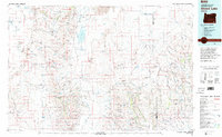
1982 Map of Alvord Lake
USGS Topo · Published 1995About this map
Steens Mountain and the Pueblo Mountains dominate this high-desert landscape in southeastern Oregon, framing the extensive Alvord Desert and the seasonal waters of Alvord Lake. This 1980s-era mapping reveals a territory defined by isolated ranching outposts and specialized mining operations. Remote landmarks like the Whitehorse Ranch and its adjacent Whitehorse Ranch Airfield anchor the eastern reaches near the Harney and Malheur county line.
Find a feature on this map
77 named features on this map. Tap any name to fly to it.
Don’t see what you’re looking for? This feature index may not catch every label — zoom into the map to look around manually.
Map Details
Editions of this 1982 Alvord Lake Map
3 editions found
Other maps of this area

1882 · Paradise
USGS Topo · 1:250,000

1886 · Disaster
USGS Topo · 1:250,000

1889 · Long Valley
USGS Topo · 1:250,000

1893 · Paradise
USGS Topo · 1:250,000

1893 · Disaster
USGS Topo · 1:250,000

1954 · Vya
USGS Topo · 1:250,000

1955 · McDermitt
USGS Topo · 1:250,000

1955 · Jordan Valley
USGS Topo · 1:250,000

1955 · Adel
USGS Topo · 1:250,000

1957 · Adel
USGS Topo · 1:250,000