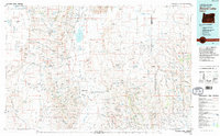
1982 Map of Alvord Lake
USGS Topo · Published 1995About this map
Steens Mountain dominates the center of this 1:100,000 scale survey, separating the high desert floor from the complex canyonlands to the east and west. In the early 1980s, the remote settlement of Andrews stood near the edge of the Alvord Desert, a region defined by seasonal water and alkali flats. The map documents a scattered resource economy through several named mining sites, including the Alvord Mine and the Lucky Star Mine, which are situated on the slopes above Pueblo Valley.
Find a feature on this map
64 named features on this map. Tap any name to fly to it.
Don’t see what you’re looking for? This feature index may not catch every label — zoom into the map to look around manually.
Map Details
Editions of this 1982 Alvord Lake Map
3 editions found
Other maps of this area

1882 · Paradise
USGS Topo · 1:250,000

1886 · Disaster
USGS Topo · 1:250,000

1889 · Long Valley
USGS Topo · 1:250,000

1893 · Paradise
USGS Topo · 1:250,000

1893 · Disaster
USGS Topo · 1:250,000

1954 · Vya
USGS Topo · 1:250,000

1955 · McDermitt
USGS Topo · 1:250,000

1955 · Jordan Valley
USGS Topo · 1:250,000

1955 · Adel
USGS Topo · 1:250,000

1957 · Adel
USGS Topo · 1:250,000