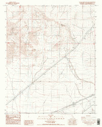
1986 Map of Alvord Mountain East
USGS Topo · Published 1986About this map
Alvord Mountain dominates this arid interior landscape, where sharp topographic rises and deep drainage systems define the high desert terrain of San Bernardino County. In the mid-1980s, this area served as a transition between public lands and restricted space, marked clearly by the Fort Irwin Military Reservation Boundary that cuts across the northern reaches of the sheet. The geological character of the region is evident in the steep contours of Alvord Peak and the carved path of Spanish Canyon. Human activity in this desolate stretch is represented primarily by infrastructure, with multiple Transmission Lines and various 4wd tracks traversing the valley floor. These primitive routes and utility corridors indicate the area's role as a rugged transit zone, connecting distant hubs across the Mojave landscape while remaining largely unpopulated.
Find a feature on this map
9 named features on this map. Tap any name to fly to it.
Don’t see what you’re looking for? This feature index may not catch every label — zoom into the map to look around manually.
Map Details
Editions of this 1986 Alvord Mountain East Map
2 editions found
Other maps of this area

1933 · Avawatz Mountains
USGS Topo · 1:250,000

1947 · Trona
USGS Topo · 1:250,000

1948 · Trona
USGS Topo · 1:250,000

1948 · Alvord Mountain
USGS Topo · 1:62,500

1948 · Cave Mountain
USGS Topo · 1:62,500

1951 · Cave Mountain
USGS Topo · 1:62,500

1951 · Alvord Mountain
USGS Topo · 1:62,500

1953 · San Bernardino
USGS Topo · 1:250,000

1953 · Trona
USGS Topo · 1:250,000

1955 · Newberry
USGS Topo · 1:62,500