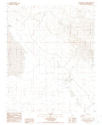
1986 Map of Alvord Mountain West
USGS Topo · Published 1986About this map
Alvord Mountain dominates the eastern landscape of this Mojave Desert region, where historical mining and water prospecting define the human footprint. The map documents the industrial legacy of the area, centered on the Alvord Mine and several scattered prospects and mines tucked into the mountain's rugged contours. To the west, the expansive bed of Coyote Lake marks a significant topographic depression, its margins dotted with vital water sources such as Jack Rabbit Spring and a series of numbered wells, including Well 1770 and Well 1764T. A network of 4wd tracks and private transmission lines crisscross the arid flats, illustrating the infrastructure required to maintain remote operations in San Bernardino County. The presence of the Alvord Well (Dry) serves as a quiet indicator of the challenges faced by those attempting to extract resources from this parched environment during the mid-1980s.
Find a feature on this map
24 named features on this map. Tap any name to fly to it.
Don’t see what you’re looking for? This feature index may not catch every label — zoom into the map to look around manually.
Map Details
Editions of this 1986 Alvord Mountain West Map
2 editions found
Other maps of this area

1933 · Avawatz Mountains
USGS Topo · 1:250,000

1947 · Trona
USGS Topo · 1:250,000

1948 · Trona
USGS Topo · 1:250,000

1948 · Alvord Mountain
USGS Topo · 1:62,500

1948 · Lane Mountain
USGS Topo · 1:62,500

1951 · Alvord Mountain
USGS Topo · 1:62,500

1951 · Lane Mountain
USGS Topo · 1:62,500

1953 · San Bernardino
USGS Topo · 1:250,000

1953 · Yermo
USGS Topo · 1:24,000

1953 · Trona
USGS Topo · 1:250,000