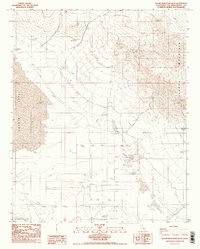
1986 Map of Alvord Mountain West
USGS Topo · Published 1986About this map
Alvord Mountain rises above the eastern Mojave Desert, defining the rugged landscape of this 1980s San Bernardino County survey. The map reveals a land shaped by the search for resources, centered on the Alvord Mine and various scattered prospect pits located in the northern and eastern highlands. This area transitions sharply into the expansive, flat playa of Coyote Lake to the west, a dry basin that dominates the lower elevations.
Find a feature on this map
21 named features on this map. Tap any name to fly to it.
Don’t see what you’re looking for? This feature index may not catch every label — zoom into the map to look around manually.
Map Details
Editions of this 1986 Alvord Mountain West Map
2 editions found
Other maps of this area

1933 · Avawatz Mountains
USGS Topo · 1:250,000

1947 · Trona
USGS Topo · 1:250,000

1948 · Trona
USGS Topo · 1:250,000

1948 · Alvord Mountain
USGS Topo · 1:62,500

1948 · Lane Mountain
USGS Topo · 1:62,500

1951 · Alvord Mountain
USGS Topo · 1:62,500

1951 · Lane Mountain
USGS Topo · 1:62,500

1953 · San Bernardino
USGS Topo · 1:250,000

1953 · Yermo
USGS Topo · 1:24,000

1953 · Trona
USGS Topo · 1:250,000