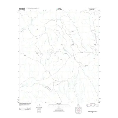
2012 Map of Amarilla Mountain
USGS Topo · Published 2012About this map
Lajitas International Airport serves as a prominent modern landmark in this high-desert region of Brewster County, where the landscape is defined by the stark relief of Amarilla Mtn and Black Mesa. The network of roads, including Mariposa Mine Rd and Solitario Saw Mill Rd, reflects the area's history of resource extraction and ranching logistics. Natural water sources like Comanche Spring and ephemeral drainages such as Comanche Cr and Well Cr have long dictated the movement and settlement patterns in this arid environment, providing essential points of interest for researchers of Trans-Pecos history. This 2012 survey also documents local sites like Coltrins Camp and the unique geological features of the Terlingua Sinkhole, Fossil Knobs, and Sierra de Cal.
Find a feature on this map
29 named features on this map. Tap any name to fly to it.
Don’t see what you’re looking for? This feature index may not catch every label — zoom into the map to look around manually.
Map Details
Editions of this 2012 Amarilla Mountain Map
This is the sole edition of this map. No revisions or reprints were ever made.
Other maps of this area

1903 · Terlingua
USGS Topo · 1:125,000

1904 · Terlingua
USGS Topo · 1:125,000

1931 · Lajitas
USGS Topo · 1:62,500

1959 · Emory Peak
USGS Topo · 1:250,000

1965 · Emory Peak
USGS Topo · 1:250,000

1971 · Yellow Hill
USGS Topo · 1:24,000

1971 · Terlingua
USGS Topo · 1:24,000

1971 · Amarilla Mountain
USGS Topo · 1:24,000
1971 · The Solitario
USGS Topo · 1:24,000
1971 · Hen Egg Mountain
USGS Topo · 1:24,000