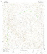
1971 Map of The Solitario
USGS Topo · Published 1974About this map
The Solitario dominates the landscape as a massive geologic dome on the border of Presidio and Brewster Counties. This 1971 survey captures the remote character of the Trans-Pecos region, where rugged terrain and drainage patterns define human access. A network of Jeep Trails provides the primary means of navigating between family-named landmarks and water sources like McGuirks Tanks and Old Log Spring. The intricate drainage system is marked by distinctive topographical narrows known as the Righthand Shutup, Lefthand Shutup, and Lower Shutup, which channel runoff toward the deep Fresno Canyon on the western edge of the dome. Scattered signs of human endeavor appear at the Burnt Camp settlement and various unnamed Mines and Prospects in the Blue Range, reflecting the area's history of isolated prospecting and ranching.
Find a feature on this map
26 named features on this map. Tap any name to fly to it.
Don’t see what you’re looking for? This feature index may not catch every label — zoom into the map to look around manually.
Map Details
Editions of this 1971 The Solitario Map
This is the sole edition of this map. No revisions or reprints were ever made.
Other maps of this area

1903 · Terlingua
USGS Topo · 1:125,000

1904 · Terlingua
USGS Topo · 1:125,000

1917 · Agua Fria
USGS Topo · 1:62,500

1917 · Tascotal Mesa
USGS Topo · 1:62,500

1931 · Lajitas
USGS Topo · 1:62,500

1937 · Agua Fria
USGS Topo · 1:62,500

1944 · Tascotal Mesa
USGS Topo · 1:62,500

1959 · Emory Peak
USGS Topo · 1:250,000

1965 · Emory Peak
USGS Topo · 1:250,000

1971 · Yellow Hill
USGS Topo · 1:24,000