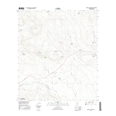
2016 Map of Amarilla Mountain
USGS Topo · Published 2016About this map
Amarilla Mountain and the surrounding high desert of Brewster County are defined by a complex network of canyons and mesas that meet the northern fringe of Big Bend National Park. The landscape shows a distinct transition from the steep elevations of Black Mesa and Clay Mtn to the flatter expanses near Lajitas International Airport. Evidence of the region's geological and mining history is clear in features like the Terlingua Sinkhole, Fossil Knobs, and the N Lone Star Mine, while the presence of Comanche Spring indicates the vital water sources that dictated settlement patterns in this arid environment.
Find a feature on this map
42 named features on this map. Tap any name to fly to it.
Don’t see what you’re looking for? This feature index may not catch every label — zoom into the map to look around manually.
Map Details
Editions of this 2016 Amarilla Mountain Map
This is the sole edition of this map. No revisions or reprints were ever made.
Other maps of this area

1903 · Terlingua
USGS Topo · 1:125,000

1904 · Terlingua
USGS Topo · 1:125,000

1931 · Lajitas
USGS Topo · 1:62,500

1959 · Emory Peak
USGS Topo · 1:250,000

1965 · Emory Peak
USGS Topo · 1:250,000

1971 · Yellow Hill
USGS Topo · 1:24,000

1971 · Terlingua
USGS Topo · 1:24,000

1971 · Amarilla Mountain
USGS Topo · 1:24,000
1971 · The Solitario
USGS Topo · 1:24,000
1971 · Hen Egg Mountain
USGS Topo · 1:24,000