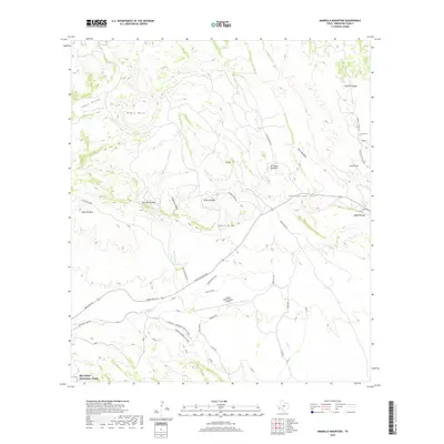
2019 Map of Amarilla Mountain
USGS Topo · Published 2019About this map
Amarilla Mtn and Tres Cuevas Mtn dominate this portion of Brewster County, where the high desert terrain transitions into the northern reaches of Big Bend National Park. The landscape is a complex network of dry canyons and seasonal watercourses, including Croesus Canyon and Well Cr, which navigate between prominent elevations like Black Mesa and Sierra de Cal. Human activity is concentrated along the arterial Ranch Rd 170, supporting the Lajitas International Airport and a series of recreational paths such as the Singlespeed Trail. Evidence of the region's geological and industrial history is scattered throughout, from the Terlingua Sinkhole to the N Lone Star Mine, illustrating the persistent effort to extract resources from this demanding environment near Comanche Spring.
Find a feature on this map
42 named features on this map. Tap any name to fly to it.
Don’t see what you’re looking for? This feature index may not catch every label — zoom into the map to look around manually.
Map Details
Editions of this 2019 Amarilla Mountain Map
This is the sole edition of this map. No revisions or reprints were ever made.
Other maps of this area

1903 · Terlingua
USGS Topo · 1:125,000

1904 · Terlingua
USGS Topo · 1:125,000

1931 · Lajitas
USGS Topo · 1:62,500

1959 · Emory Peak
USGS Topo · 1:250,000

1965 · Emory Peak
USGS Topo · 1:250,000

1971 · Yellow Hill
USGS Topo · 1:24,000

1971 · Terlingua
USGS Topo · 1:24,000

1971 · Amarilla Mountain
USGS Topo · 1:24,000
1971 · The Solitario
USGS Topo · 1:24,000
1971 · Hen Egg Mountain
USGS Topo · 1:24,000