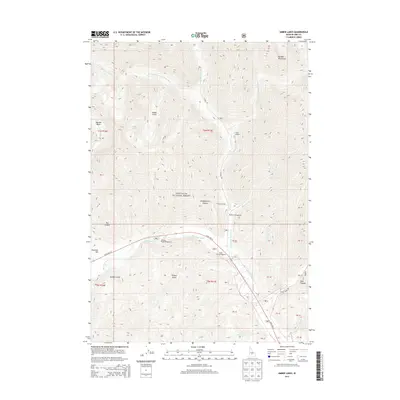
2013 Map of Amber Lakes
USGS Topo · Published 2013About this map
Sawtooth National Forest dominates this Idaho landscape, where the high-altitude topography of the Boulder Mountains shapes the upper reaches of the Big Wood River system. The drainage network is clearly defined by the W Fork N Fork Big Wood River and the N Fork Big Wood River, which converge as they flow south. The presence of several established recreational sites, such as Camp Manapu, Camp Sawtooth, and Murdock Campground, highlights the area's long-standing use as a public retreat within the forest boundaries.
Find a feature on this map
32 named features on this map. Tap any name to fly to it.
Don’t see what you’re looking for? This feature index may not catch every label — zoom into the map to look around manually.
Map Details
Editions of this 2013 Amber Lakes Map
This is the sole edition of this map. No revisions or reprints were ever made.
Other maps of this area

1895 · Hailey
USGS Topo · 1:125,000

1897 · Hailey
USGS Topo · 1:125,000

1900 · Sawtooth
USGS Topo · 1:125,000

1955 · Hailey
USGS Topo · 1:250,000

1959 · Hailey
USGS Topo · 1:250,000

1962 · Hailey
USGS Topo · 1:250,000
1967 · Meridian Peak
USGS Topo · 1:24,000

1967 · Rock Roll Canyon
USGS Topo · 1:24,000

1967 · Sun Valley
USGS Topo · 1:24,000
1967 · Griffin Butte
USGS Topo · 1:24,000