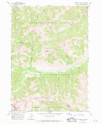
1967 Map of Meridian Peak
USGS Topo · Published 1971About this map
Meridian Peak stands as the central landmark in this high-elevation wilderness within the Boulder Mountains, where the headwaters of the North Fork Big Lost River begin their descent. Surveyed in the late 1960s, the map detail focuses on the convergence of the Sawtooth National Forest and the Challis National Forest along the Custer and Blaine County line. This area is defined by its lack of established roads, relying instead on a system of pack trails and a jeep trail to navigate the steep drainages of Hunter Creek and Squib Canyon. A lone Prospect located south of Slide Canyon indicates the history of mineral exploration that periodically reached these isolated heights. The presence of named water sources like Little Fall Cr Springs and Spring suggests the vital importance of seasonal water for both livestock and early travelers crossing Hunter Creek Summit.
Find a feature on this map
24 named features on this map. Tap any name to fly to it.
Don’t see what you’re looking for? This feature index may not catch every label — zoom into the map to look around manually.
Map Details
Editions of this 1967 Meridian Peak Map
2 editions found
Other maps of this area

1895 · Hailey
USGS Topo · 1:125,000

1897 · Hailey
USGS Topo · 1:125,000

1929 · Bayhorse
USGS Topo · 1:125,000

1955 · Hailey
USGS Topo · 1:250,000

1957 · Challis
USGS Topo · 1:250,000

1959 · Hailey
USGS Topo · 1:250,000

1960 · Challis
USGS Topo · 1:250,000

1962 · Hailey
USGS Topo · 1:250,000

1963 · Challis
USGS Topo · 1:250,000
1963 · Bowery Peak
USGS Topo · 1:24,000